Monday, May 13, 2013

Home, Sweet Home??? (Coordinates: 20°26'10.52"S, 150°26'55.21"E)

After all of my adventures chasing plate tectonics (and getting chased), it seems rather tame to be back at home in my little reef. I'm afraid I'm not cut out for life as a normal fish; I much prefer the excitement and chase of seeking out science. Perhaps I'll branch out into marine biology.

Anyway, you didn't come here to listen to me whine about the life of a clownfish. You clearly came here to get the link to my Google Earth tour! Squirt and I wanted to share a more visual aspect of our journey. Unfortunately, here in the Great Barrier Reef, we don't have great computers, so I'm not able to upload it right now. If I do so in the future, you'll be the first to know! See you during my next adventure!
*UPDATE*: Go to this site for the tour.
https://sites.google.com/site/fadsjfklasdfjlksadj/google-earth-tour/Nemos%20Tectonic%20Tour%20Trip%20Time%21.kml?attredirects=0&d=1


Wednesday, May 8, 2013

Mid-Atlantic Ridge: A transform boundary within a divergent boundary! BOUNDARY-CEPTION! (Coordinates: 0°30'9.46"S, 19°57'33.41"W)

I know, I know, two blog posts from the same place! You're all like, "What's with Nemo? Has he finally gone off the deep end?" Well, I did, back at the Mariana Trench. But anyway, the Mid-Atlantic Ridge is a fascinating place, and guess what? There is a place like it in the Pacific called the East Pacific Rise! How lucky for all us from the Pacific. Yes, it is a divergent boundary, but there's more! At different points, the two plates are pulling back and forth alongside each other instead of apart. So there are transform boundaries hidden along the divergent boundary. Two kinds of plate tectonics in one place! It's like a dream come true... I bet you're itching to hear the science, so check it out below:
As you should be able to see in this picture, along mid-oceanic ridges created by divergent boundaries, there are transform faults where two plates rub back and forth against each other. These are major earthquake hubs; the famous San Francisco earthquake of 1906 was caused by a rupture on the San Andreas Fault, a transform boundary, although it is on land. I just can't believe that mid-oceanic ridges can contain transform boundaries and divergent boundaries! It's like inception! Adios, amigos! Au revoir.

The Mid-Atlantic Ridge: A divergent boundary! I'm back in the ocean...after what I shall call a WHALE! (Coordinates: 2°43'17.99"N, 30°49'45.04"W)

Squirt was looking for an adventure! We decided to swim down the entire Mid-Atlantic Ridge, but it didn't work so well... Turns out whales at divergent boundaries aren't there to appreciate the plate tectonics, just to  EAT INNOCENT MARINE LIFE! Luckily, Dory speaks Whale, so after a little bit of sweet talk, and a lot of time, we were exhaled through the whale's blowhole. However ironic it may be, we did end up swimming along most of the Mid-Atlantic Ridge, although we were inside a whale. It was dark, it was cold, it was slimy and it was quite educational. Even if the whale didn't enjoy the fascinating plate tectonics science, I sure did, and I think you will too!

As you can see in this drawing, which I did myself, in divergent boundaries tectonic plates are moving apart and leaving a gap, into which magma from the mantle upwells to fill the hole. The magma hardens, and over time, slides down both sides of the gap, creating two strips of precisely identical rock on either side.  However, there are still fracture zones along the ridges, where there is lots of earthquake activity. There are also many underwater volcanoes formed by the magma which upwells. 

The rocks in the diagram are colored to represent the two different alignments of minute metal fragments in the rock, pointing either north or south, showing which way the magnetic field surrounding Earth was aligned when the rocks cooled. The farther you get from the center of the ridge, the colder and older the rocks are. That means that the center of the Mid-Atlantic Ridge should have been warm. But we were still cold, so I guess maybe whale insides are just cold. See you at our next stop! HINT: It's a transform boundary!


Tuesday, May 7, 2013

The Himalayas: FISH OUT OF WATER! In a continent-continent collision boundary! (Coordinates: 30°37'58.08"N, 79°48'57.18"E)

Well, here I am, live from the Himalayas! Yes, on land! Those Himalayas! I said it was a surprise! How did I get here? My adoring fans are carrying me around, and I'm in a plastic baggie, just like back in the dentist's office. Aah! That's Darla! Hide me, #1 Fan number 56874! No, you don't have to type that. So, anyway, I am here, at a boundary between tectonic plates, specifically a collision boundary between continental plates. You might be wondering how the science works for this, so look at this picture below!
The continental plates collide, and neither really gives way, so after many earthquakes, the two plates push against each other until mountains are formed and the plates weld into a larger continent. This is how the Indian subcontinent became attached to the larger Eurasian plate. Did you know that this is how the Himalayas were formed? And did you know that the Himalayas are not volcanoes? When the mountain ranges are created by the collision of continental plates, no magma is forced up from the mantle, so the mountains do not become volcanoes. However, there is still earthquake activity due to the plates rubbing against each other.
I hope I'll see you in my next destination. Squirt picked it, and he won't tell me what it is! I have to go now and get back in the ocean soon. This Ziploc makes me nervous.


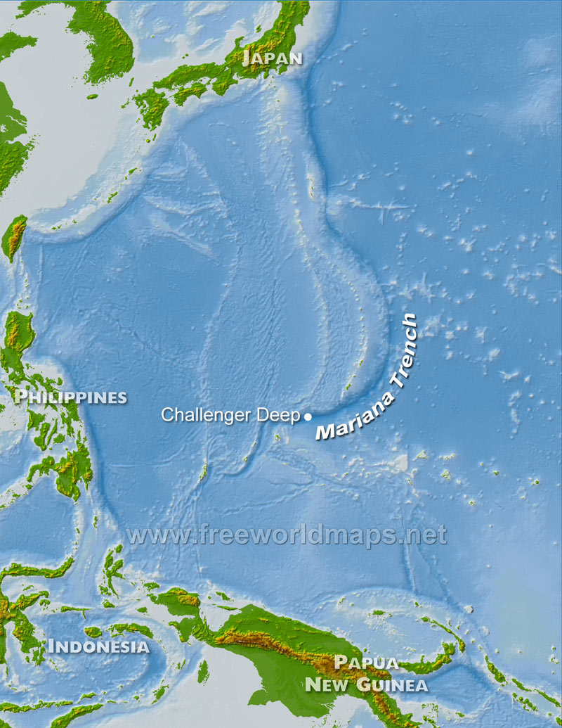
Mariana Trench: An example of ocean-ocean subduction! (Coordinates: 11°19'0.09"N, 142°14'59.98"E)

Did you know that the Mariana Trench is one of the deepest parts of the ocean? It's also really dark. My dad nearly had a panic attack just thinking about all of the anglerfish that could be out to get me! He's still a little overprotective. Did you know that the Mariana Trench is also called the Marianas Trench? It was formed by the convergence of the Pacific Plate and the Philippine Plate. The heavier Pacific Plate subducted underneath the Philippine Plate, creating a trench in the ocean floor. The Pacific Plate also pushed upwards on the Philippine Plate from underneath, creating a chain of volcanic islands, the Mariana Islands.

This picture shows how volcanic island chains and ocean trenches are created by ocean-ocean convergence. The islands often have large volcanoes because they are pushed upwards to create mountains and contain magma. Earthquakes are caused often by the plates colliding and sometimes can be very dangerous. The deadly 2011 Japan earthquake and tsunami was caused by ocean-ocean convergence.

Squirt says he doesn't know any of that because he wasn't paying attention. He was too busy seeing how deep he could dive. Turns out he can dive pretty deep, and he got lost for a while, and Dory had to go rescue him! Luckily, he didn't run into any anglerfish or sharks. Well, I should probably get to sleep; we have a long journey ahead of us to get to our next stop. I can't tell you what it is because it's a surprise!

Monday, May 6, 2013

Tectonic Tour: Trip Time! (Coordinates: 20°26'10.52"S, 150°26'55.21"E)

Hi. I'm Nemo. From Finding Nemo, you know, that movie? The one with the fish? Yeah, I'm a fish. I type with my nose. Kidding! I dictate. Well, anyway, I had quite an adventure, but it's not over yet. My friend Squirt wanted to see more of the world, so my father Marlin and his friend Dory decided to take Squirt and me on an educational tour, of tectonic plate boundaries, of all things!

And yes, this is my project. We visited four different types of plate boundaries, and some of them weren't even in the ocean! I was so excited by our trip that I decided to tell the world all about it. I hope you like my blog and I can't wait to share all of my adventures!

Image credit: http://crossfitsomerville.com/2013/02/07/nemo/